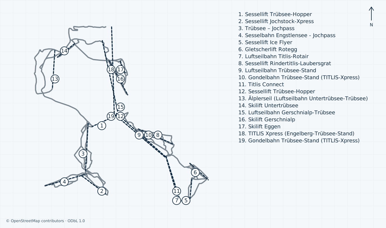
Managed alpine skiing above Engelberg, linking the Trübsee plateau with Stand and the Titlis glacier on one side and Jochpass, Jochstock and Engstlenalp on the other.
Independent ODbL community geometry covers the reviewed Engelberg–Gerschnialp/Untertrübsee–Trübsee–Stand–Titlis and Jochpass–Jochstock/Engstlenalp managed alpine extent. Brunni/Klostermatte, neighbouring ski areas, restricted Trübsee chair and ski-jump transport, unidentified pony/snowtubing lifts, goods/zip lines and backcountry/freeride terrain are excluded. The Gerschnialp funicular is not an aerialway and is absent from this map; its actual operation must be checked separately. Several OSM sections represent one installation, so neither way segments nor the lift key are an operator inventory. Community names/references and construction-era alignments are not a verified current operator plan; unconfirmed local colours remain grey. Original canonical OSM API tile HTTP dates supply the snapshot interval, not an Overpass replication timestamp. Unconfirmed: the host’s winter-map landing controls are verified, but current artwork edition, native rendering and remote-preview or reproduction rights are unverified; no operator map artwork is copied or embedded. Geometry and the 2005 photograph establish no current skiing, access permission or safe navigation.
Access: Confirm the Xpress approach, summit Connect/Rotair arrangements and each actual open managed descent.
High alpine managed terrain; a planned glacier start does not open every lower sector or freeride route.
02
Trübsee, Jochpass, Jochstock and Engstlenalp
Access: Check the plateau crossing and both outward and return chairlift connections before leaving Trübsee.
Separate western ski sectors with different planned dates and last chair times.
03
Gerschnialp, Untertrübsee and valley return
Access: Use only the signed open lower pistes and confirm funicular, Älplerseil or gondola return as appropriate.
Lower learning terrain and descents have separate seasons; Brunni/Klostermatte are outside this guide.
01
Starting base: Titlis valley station in Engelberg
Use the Gerschnistrasse 14 base and check the current rail or road approach. The pin is an OSM cableway endpoint; it does not promise parking, a bus connection or an accessible transfer. Brunni/Klostermatte are separate.
02
Connections: Trübsee divides the two mountain sides
From Trübsee the summit approach runs through Stand; Jochpass and Engstlenalp lie across the plateau. The winter Hopper carries winter-sports users, not pedestrians. Check each link, summit construction arrangements and sector opening before crossing.
03
Return: work back from your final valley connection
Final piste inspections and individual chair/cableway closing times are different. Unconfirmed: your complete last ski-and-lift descent, plateau transfer and onward final bus/train are not established; ask staff before ascending and allow time for connections.
Plan distinct glacier and lower-sector seasons, summit construction access, the Trübsee crossing and the complete valley return. This guide excludes Brunni, neighbouring areas and freeride descents.
Separate glacier and lower-sector calendars
Trübsee connections and complete return planning
Licensed independent whole-area map
Managed glacier, plateau and western sectors
The managed Titlis area rises from Engelberg through Trübsee and Stand to the glacier, while Jochpass branches west towards Jochstock and Engstlenalp. Gerschnialp and Untertrübsee supply lower learning terrain and return connections. The operator describes blue, red and black alpine pistes. These are local grades; the independent map keeps unconfirmed OSM grades grey. Brunni, Klostermatte, Fürenalp, neighbouring ski areas, Nordic tracks and touring terrain are separate.
Conflicting sources: the English skiing page plans the glacier for 29 October 2026–2 May 2027, whereas the retained freeride page still gives 10 October. The English ski plan lists Jochpass 5 December–11 April, Gerschnialp 5 December–29 March, Engstlenalp/Jochstock and the valley descent 12 December–11 April, and Untertrübsee 19 December–11 April. The freeride block instead gives 19 December for Engstlenalp/Jochstock, 5 December for the valley descent and a different Untertrübsee end. These are published plans, not current open sectors; check a dated report before travel.
Partial opening: the host-tourism report dated Tuesday 3 November 2026 marks 1a Ice Flyer and 1b Glacier open, with the Ice Flyer chairlift and summit access operating. This establishes limited public glacier skiing, while other sectors and complete valley return remain separate. The ODbL map covers community geometry within the reviewed managed extent; it is not a current operator inventory, navigation aid or opening report.
Summit replacement, the Trübsee crossing and final return
The normal Xpress approach runs Engelberg–Trübsee–Stand, followed by summit cable transport. The operator timetable says Rotair is closed 17 August–11 December 2026 with TITLIS Connect as replacement; the Gerschnialp funicular is separately closed 2–13 November. The dated 3 November host report repeats the funicular maintenance while showing the limited glacier offer open. The independent aerialway map omits that railway, unidentified learning lifts and the restricted Trübsee chair; mapped old/new summit alignments do not guarantee a usable construction-era connection.
For winter planning, the timetable lists Hopper 5 December–11 April 08:45–16:30, Jochpass 5 December–11 April 09:00–16:15, and the Engstlen chair 19 December–11 April 09:30–16:00. Hopper is for winter-sports users, not pedestrians. Conflicting sources: the ski-page Engstlenalp slope plan starts 12 December, one week before the chair timetable. Do not use either date as proof of a through connection.
The general summit transport row is 08:30–17:00 with final ascent to Titlis 15:30, while the Xpress section row ends 17:15. Final piste inspections are listed at 16:10 Titlis–Stand, 16:20 Stand–Trübsee and 16:30 Jochpass–Trübsee/Trübsee–Engelberg. These checks are not final boarding promises. Unconfirmed: installation-specific ski-lift hours for the actual day and your complete last return are not established; work backwards through every chair, plateau transfer and valley connection with staff.
Partial opening: the 3 November 2026 host-tourism report marks Titlis pistes 1a Ice Flyer and 1b Glacier open, with the Ice Flyer chairlift and summit access operating. The Gerschnialp funicular is closed for maintenance from 2 to 13 November. Other sector dates remain separate planned calendars; this limited glacier offer does not establish all-area skiing or a complete valley return.
Engelberg arrival and construction-era mobility limits
The practical base is Titlis Cableways at Gerschnistrasse 14, 6390 Engelberg. The host recommends rail via Lucerne and Zentralbahn to Engelberg; by road, leave theA 2 at Stans-Süd and follow the Engelberg approach. Check the actual railway stopping pattern, road/weather conditions and onward connection for your date. The map pin is the retained lower Xpress endpoint, distinct from Brunni/Klostermatte and from a reserved parking space.
The host advertises a free valley bus between the railway and mountain stations, with an explicit low-season exception. Unconfirmed: a particular 2026/27 winter departure, final bus, current parking charge/capacity, overnight permission and the complete station-to-lift transfer are not established here. Use the current timetable and signs, rather than treating a general free-bus description or road-time estimate as a connection guarantee.
The operator’s construction notice limits wheelchairs and pushchairs to Trübsee through 12 December 2026. It describes restricted summit access from 13 December during redevelopment, and notes escalators rather than lifts for glacier access. Conflicting sources: the transport row ends Rotair maintenance 11 December, while the mobility notice keeps its restriction through 12 December. Do not infer assisted summit or ski access from the earlier date. Agree equipment, boarding, assistance and the complete suitable return directly with the operator; general wheelchair access to Trübsee does not establish an adaptive ski journey.
Choose ski entitlement separately from sightseeing transport
The operator sells dynamically priced ski day passes; select the actual skiing date, age and open-area entitlement before comparing prices. Its smaller-area Trübsee product covers the area between Trübsee and Engelberg, while the Gerschnialp product includes Gerschnialp and the Untertrübsee ski lift. Both have full-day and half-day options, with half-day starting at 12:00. These products do not establish an open glacier or a connected return.
The published price page shows adult one-day Trübsee/Gerschnialp amountsCHF 44/31 and half-dayCHF 35/25, but does not clearly date those rows to the coming ski season. Unconfirmed: these undated tariff rows have no established ski-season applicability and are not a current purchase quote. Pedestrian cableway fares and their rail discounts form separate tables and must not be read as ski-pass prices or interchangeable eligibility.
Unconfirmed: your final date-specific ski fare, exact age boundaries, card/deposit charges, discount combinations, weather cancellation/refund outcome and any cross-area entitlement are not established by these general pages. Read the conditions shown for the selected product before payment. A pass sale, AlpsPass pre-sale or transport ticket is not evidence that the ski sector is open.
Open managed pistes only; no freeride or after-hours permission
Stay on signed open managed pistes and obey closures, weather decisions and transport staff. Confirm the exact available sector and return route before going up; a lower-sector closure cannot be solved by following an old map line. High altitude, exposed terrain and rapidly changing mountain weather need suitable equipment and conservative decisions. The current preview and seasonal plans supply no guarantee of today’s surface, grooming or patrol coverage.
The operator identifies Laub, Galtiberg, Steinberg, Sulz and Steintäli as freeride terrain and recommends qualified mountain guides and current avalanche information. Those descents, other backcountry lines, glacier tours and unguided off-piste alternatives are excluded from this managed-piste map. Do not enter closed or out-of-hours pistes or assume uphill permission; an independent community line and old photograph provide none.
The operator’s mountain emergency number is+41 41 639 50 61; its SOS page also gives 144 for Swiss medical emergencies. Give the precise signed location, callback number, incident, affected people and hazards, and remain on the call until the details are understood. The general office+41 41 639 50 50 is separate. Unconfirmed: current patrol deployment, rescue response/cost, an individual assisted evacuation and a complete safe late return have not been established. Arrange special requirements before buying or ascending.
Book village equipment, tuition and mountain services separately
The host lists independent equipment shops and separate ski/snowboard schools. Swiss Ski School Engelberg advertises 2026/27 group/private options and gives Parkweg 1, +41 41 639 54 54 and info@skischule-engelberg.ch. Prime Mountain Sports gives its current Dorfstrasse 31 address, +41 41 637 01 55 and time@prime-engelberg.ch; its own move notice supersedes the older Dorfstrasse 34 address in the historical brochure. Choose the exact discipline, level, lesson area and meeting point before reserving.
Unconfirmed: a particular early-season lesson, open teaching sector, adaptive tuition arrangement, rental stock, fitting slot, collection branch, equipment compatibility and final return deadline are not established by these directories. Arrange the actual rental collection and lesson before travel. Allow time to fit equipment and return it after the mountain journey; a village office opening does not extend ski transport or guarantee a bus.
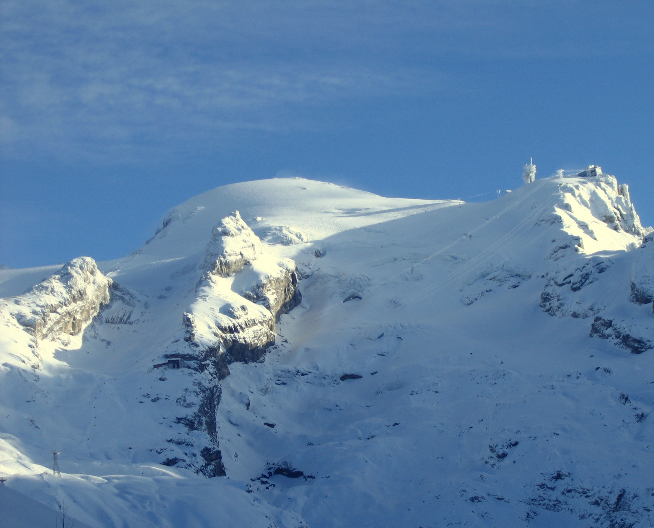
Titlis Cableways publishes titlis@titlis.ch and+41 41 639 50 50 at Gerschnistrasse 14. Host tourism gives welcome@engelberg.ch and+41 41 639 77 77 at Hinterdorfstrasse 1. Confirm restaurant tables, accommodation, storage and any construction-affected service separately from lift access. Historical: the genuine photograph shows Titlis inJanuary 2005; snow, glacier and summit infrastructure have changed, and the image establishes no present skiing or accessible route.
Selected historical name and local-grade references only. The coverage note explains the unavailable current official plan. This list establishes neither the full inventory nor current opening or access.
04 / AT THE BASE
Facilities that change the day.
Independent village rental shops and ski/snowboard schools Mountain restaurants booked separately from ski transport Construction-era mobility restrictions require individual journey planning
05 / PROFILE BASIS & SOURCES
What this profile is based on.
This profile is based on current information published or supplied by the place or its operator and the dated sources linked below.
SOURCE CHECKED
Initial independent ten-scope review: managed area, exact source conflicts, current-status uncertainty, construction/mobility limits and complete-return planning. Full, geometry and media checks are separate.
AUTHENTIC OPEN-LICENSE PHOTO · 2026-11-03
The hero image is an authentic photograph by Mussklprozz, reused under the CC BY-SA 4.0 license.
Historical: genuine 1 January 2005 winter photograph of Titlis and its glacier from Trübsee by Mussklprozz, CC BY-SA 4.0. The older snow, glacier and summit infrastructure do not establish current conditions, construction layout, skiing or access. Exact original retained; responsive crops only.