Plan Cerro Bayo’s managed alpine terrain above Villa La Angostura with an independent map, orientation from the mountain base to Cota 1500, and sourced advice on sector connections, tickets, arrival, safety and the return.
Villa La Angostura, NeuquénCerro Bayo mountain base, Villa La Angostura, Neuquén, Argentina
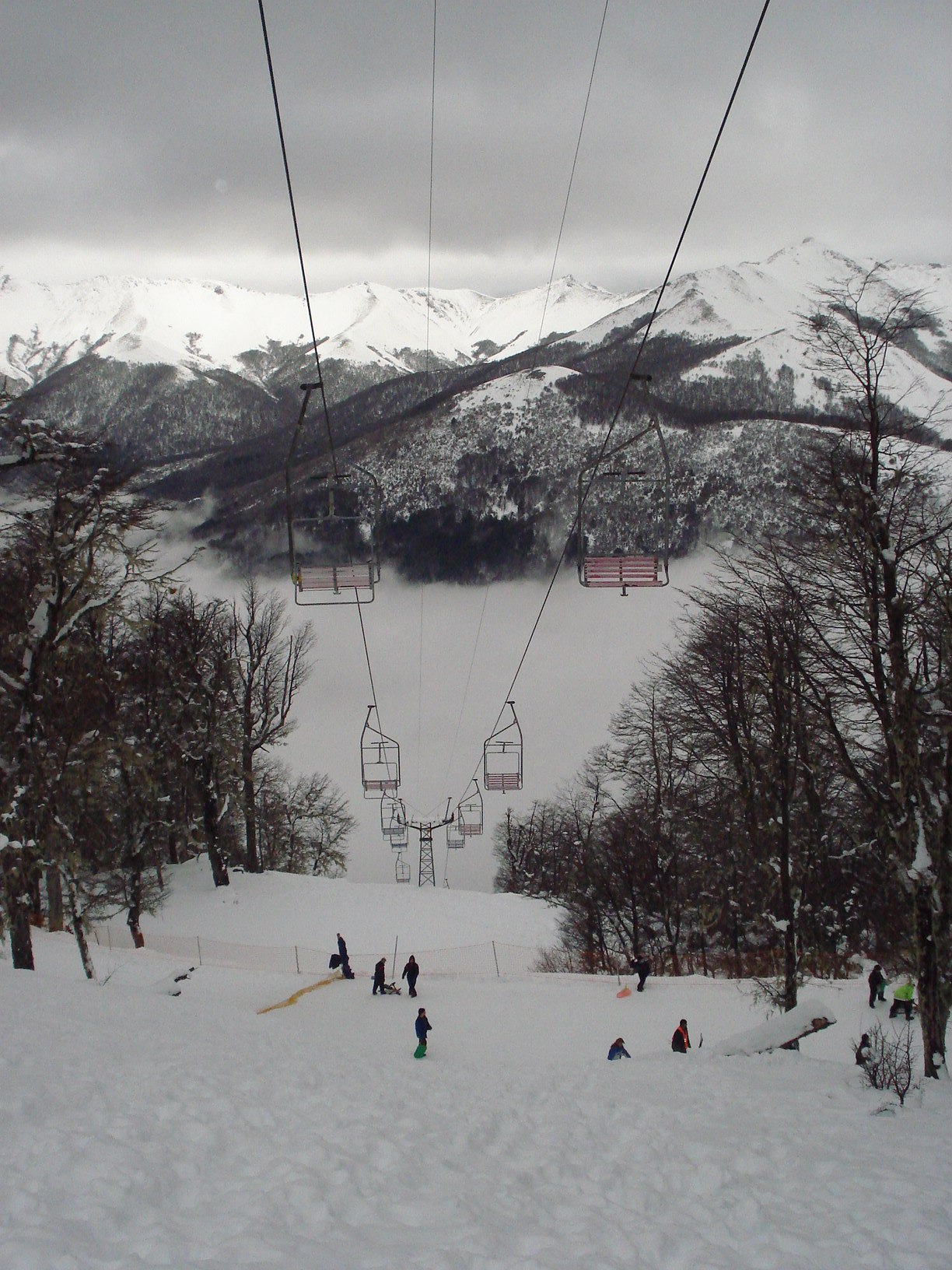
AUTHENTIC OPEN-LICENSE PHOTOPhoto: Miguel Errasti / Miguel Errasti / Wikimedia Commons · CC BY-SA 4.0Historical: Cerro Bayo, 2 August 2006. Miguel Errasti · CC BY-SA 4.0; original image with responsive display crops.
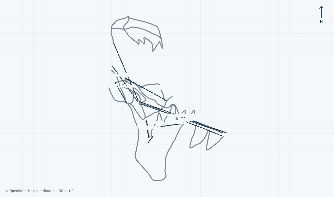
SKI AREA LAYOUTThe operator technical page advertises 24 pistes and 14 km, separately from four unpatrolled off-piste itineraries. The independent map’s 26 community downhill segments are not 26 distinct pistes or an official inventory.
UPLIFTThe technical source lists 11 installations: two gondolas, six double chairs and three carpets. The independent map retains 11 community passenger alignments; matching totals do not prove a current complete footprint or operation.
LOCAL DIFFICULTYThe operator uses local green for beginners, blue for intermediate, red for advanced and black for expert terrain. No individual colour is assigned from a generic community difficulty tag; unconfirmed map grades remain grey.
SKIING CHARACTERAlpine
MAPS / UNDERSTAND THE AREA
See how the mountain connects.
Explore the independent community map and practical starting bases. Read the coverage limits and check current opening and access with the operator.
↑ N
Open for skiing
Closed today · opening within 14 days
Closed for skiing
Unknown / uncertain
Colours show the published skiing status or confirmed operating calendar, not whether every lift is running. Check the operator before travel.
Confirmed dates change colours automatically in the place’s local time. Tentative dates, conflicting reports and expired checks remain black.
Unconfirmed: the operator map page is linked separately, but a current artwork edition and lawful inline preview have not been verified; no operator artwork is reproduced in this guide. The inspected independent ODbL extent covers lower Jean Pierre/Principal/Chaltén corridors, Cota 1500 learning, central Bosque/Lenga/Los Lagos and the separately mapped Cumbre/Provinciales branch. Its 26 downhill segments and 11 passenger alignments are community objects, not the operator inventory. Anonymous, uncorroborated, sledging, freeride and backcountry features are omitted. Unconfirmed grades remain grey. No current installation footprint, opening, permitted access, continuous connection, safe return or navigation is established.
Access: Community Jean Pierre, Principal, Chaltén and Panoramica alignments
The lower arrival and lift corridors. The daily report lists the Área 1200 separately; a mapped lower run is not proof of a skiable return to the base.
02
Cota 1500 and central mountain
Access: Learning carpets and community Bosque, Lenga and Los Lagos corridors
The operator locates beginner equipment collection and lessons around 1500. Ask an instructor for an open progression; community segments do not certify a learner-safe connection.
03
Cumbre and Provinciales
Access: Community Cumbre gondola and separately listed northern alpine corridors
The higher branch and the daily report’s Cañadón Provinciales area. Uncorroborated traverses and off-piste lines are omitted; the map does not establish a continuous open journey.
01
Start at the mountain base and arrange the upper lesson
The Jean Pierre corridor links the lower base with Cota 1500 in the operator descriptions. First-time learners are directed to collect rental equipment at 1500 near lessons. Confirm your actual boarding assistance, ticket and lesson meeting point; the town office is separate.
02
Check the open connection before changing sector
The operator daily report distinguishes the learning area, centre, Área 1200, Provinciales and T-Bar area. The independent map shows a conservative subset of community corridors, with doubtful traverses omitted. Ask staff for an opened marked connection suited to your level; pedestrian lift service is not a ski link.
03
Confirm the entire return before the last ascent
Ask staff for the final sector connection, permitted skier download and return to your exact rental and transport pickup. Future winter final times remain unconfirmed. A mapped lower piste, scenic timetable or unpatrolled shortcut cannot establish a safe skiing return.
Cerro Bayo managed alpine guide with an independent map, Cota 1500 learning area and sourced ticket, arrival, lift, safety and return advice.
Independent map of managed alpine corridors
Cota 1500 learning and rental orientation
2026 skiing closure separated from pedestrian service
Choose managed terrain and keep advertised figures in scope
Cerro Bayo is the managed alpine ski area above Villa La Angostura in Neuquén, overlooking the Nahuel Huapi setting. The technical page advertises 24 pistes and 14 km, with the learning area around Cota 1500. Its four off-piste itineraries are described separately as unpatrolled and are outside this guide and map.
Conflicting sources: the technical page lists 126 hectares of ski domain, while the location page advertises 200 hectares of alpine pistes. Their boundaries and measurement dates are not reconciled; neither figure is presented here as a verified current managed area.
The independent map retains 26 named community downhill segments and 11 passenger ways across the lower mountain, Cota 1500, central corridors and the northern Provinciales branch. These are dataset objects, not distinct pistes, an official inventory or evidence of present opening. Anonymous connections, doubtful identities, sledging and freeride/backcountry ways are omitted; generic difficulty stays grey.
Historical: Miguel Errasti’s photograph is dated 2 August 2006. It shows snowy woodland, a chairlift and mountain scenery at Cerro Bayo; it does not establish today’s installations, snow or access.
Separate skiing from pedestrian service and confirm each connection
The operator technical table places Jean Pierre between the lower base and approximately 1500, and Cumbre between that level and the upper mountain. It lists six double chairs and three learner carpets in addition to the two gondolas. The rental page directs first-time learners to collect equipment at 1500 rather than make their first chairlift journey carrying unfamiliar equipment.
Conflicting sources: the technical page calls Jean Pierre and Cumbre four-person gondolas, while the queried community data records eight-person cabins. Cabin capacity has not been independently resolved; the map shows alignments without asserting either capacity.
The ticket page checked on 1 November explicitly says the 2026 skiing season has finished. Its 09:00–17:00 description concerns pedestrian access via Jean Pierre to Cota 1500. The daily report checked on 1 November is dated 30/10 and also describes pedestrian activities. Displayed lift hours and blank extracted state icons are not a ski-opening report.
Unconfirmed: future daily skiing hours, open sector links, final boarding and skier-download arrangements are not established. Before leaving the base or changing mountain branch, ask staff for the permitted open route and complete return to your rental and transport pickup; a community line supplies no such guarantee.
Arrange the mountain journey separately from the town office
Use Villa La Angostura as the town reference and confirm the actual Cerro Bayo mountain-base approach before setting off. The operator contact page locates its administration office at Bv. Pascotto 109, Local 6, in town. That office is not the lower gondola boarding point shown by the independent planning pin.
Historical: the undated arrival page retains airline and coach names, approximate drive times and distance fields with no numerical values. It is a planning lead for travel via Bariloche or Villa La Angostura, not a verified future winter service timetable or promise of journey time.
Unconfirmed: current mountain-road restrictions, chain requirements, parking capacity, public-transfer stops, departures, fares and last return are not established by the reviewed sources. Check current official road/weather advice and obtain the exact pickup and return from your transport provider. Allow time for ticket collection, equipment fitting and the ascent to a lesson.
Unconfirmed: an individual accessible journey from transport through the base, gondola, toilets and lesson meeting point has not been verified. Contact the adaptive school and visitor team in advance about your equipment, companion, boarding assistance and return; an adaptive lesson offer is not a step-free travel guarantee.
Buy the correct activity and treat retained tariffs as dated
The tariff page checked on 31 October displays a pedestrian product at ARS 68,300 for the Mayor category and ARS 55,400 for Menor, bought at the ticket office. It describes one ascent and descent to Cota 1500 plus permitted walking areas, with no chip card. These amounts are pedestrian prices, not ski-lift day fares, and remain subject to change.
The pedestrian definitions place ages 6–11 in Menor and 12–64 in Mayor, with separate senior rules. A skiing pass and its proximity card have different scope: the retained mountain terms describe personal, nontransferable use for the contracted period. Check your exact category, card cost, inclusions and current contract before buying.
Historical: the tariff page retains 2026 seasonal bands and the general conditions retain 2026 service and tourism-programme terms, including separate cancellation and rebooking provisions. These do not establish a future skiing calendar, a 2027 ski price or universally refundable booking.
Unconfirmed: the school tariff page announces a forthcoming 2027 presale, but final future ski-pass, rental and lesson prices and the applicable complete booking conditions are not established. Request the actual dated quote for your group and activity; a pedestrian ticket cannot substitute for skiing access.
Follow local grades, staff instructions and the managed boundary
The operator’s safety page defines green as beginner, blue as intermediate, red as advanced and black as expert. Follow the actual local signs, closures and staff directions. The independent map does not convert generic community grades into those colours or establish snow quality, grooming or current access.
Control speed for visibility, terrain and other users, give downhill skiers priority and yield when joining a piste. Avoid stopping in narrow or blind places. The published rules require ski brakes and snowboard retention, and helmets for children under 14; the school has additional child-lesson requirements. Arrange correctly fitted equipment and ask the instructor about your group’s exact rule.
The technical source expressly calls the off-piste itineraries unpatrolled. The mountain terms warn that rescue outside opened pistes or after permitted hours can be charged to the user. Those lines, technical objects and uncertain shortcuts are excluded here. Remain on marked opened terrain appropriate to your ability and confirm the return before the last ascent.
For a mountain emergency, the published patrol number is +54 9 294 430 4261. Alert patrol, give the signed location and follow staff instructions. Use the chair safety bar; if a lift stops, remain in place and await evacuation instructions. The map and photograph are planning context rather than navigation or a rescue guarantee.
Coordinate equipment collection, lessons and individual support before travel
The operator lists equipment rentals at the mountain base and Cota 1500, with advance collection arrangements and consecutive-day rental scope. First-time learners are directed to the upper rental near their lesson. Confirm actual stock, fitting, helmet inclusion, storage and return location; changing mountain branch must not leave equipment or transport on the wrong side.
The school describes group and private ski/snowboard lessons, matching participants by ability. Its adult group description uses 11:00–13:00, at least four participants and consecutive days, with shorter teaching time below that minimum. Historical or undated service descriptions are not confirmation that lessons operate now.
Conflicting sources: the retained children’s tariff text gives different starting weekdays for Copitos and Bayitos in separate paragraphs. Obtain your child’s exact age group, dates, meeting point, meal/collection arrangements and written booking conditions rather than choosing one of those schedules.
The adaptive page describes individual assessment, specialist equipment and booking at least 24 hours ahead; it publishes 0294 459 2217 for enquiries. The general terms require a responsible companion and restrict permitted terrain. Confirm the current CUD policy, eligibility, companion pass, equipment and instructor availability for your circumstances instead of assuming every disability or lift can be accommodated.
The dining page locates Tronador beside the ski school and lists other mountain venues with season-dependent hours. The contact page gives mountain visitor assistance as +54 9 294 423 4828, described for visitors on the mountain from 09:00 to 17:00. Confirm current food, toilets, assistance and last service before ascending; these descriptions do not reopen the ski season.
Selected historical name and local-grade references only. The coverage note explains the unavailable current official plan. This list establishes neither the full inventory nor current opening or access.
04 / AT THE BASE
Facilities that change the day.
Mountain-base and Cota 1500 equipment rental Operator ski/snowboard school and individually arranged adaptive instruction Mountain dining and separate visitor assistance
05 / PROFILE BASIS & SOURCES
What this profile is based on.
This profile is based on current information published or supplied by the place or its operator and the dated sources linked below.
COMMUNITY REPORTED
All ten full-review scopes checked against actual operator text. Explicit 2026 skiing closure is separate from pedestrian services; future winter dates and transport remain unknown. Area and gondola-capacity source conflicts, retained contracts and archive imagery are labelled. Independent map and media clocks remain separate.
AUTHENTIC OPEN-LICENSE PHOTO · 2026-10-31
The hero image is an authentic photograph by Miguel Errasti, reused under the CC BY-SA 4.0 license.
Genuine own-work Cerro Bayo winter photograph dated 2 August 2006, uploaded 21 October 2014. Original 1224 × 1632 JPEG bytes retained; responsive CSS crops under CC BY-SA 4.0. Historical resort context, not a current snow, lift or operation report.